Storm Yutu has weakened as it entered the East Sea on the morning of October 31, according to the National Centre for Hydro-Meteorological Forecasting.

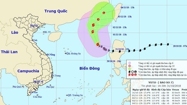
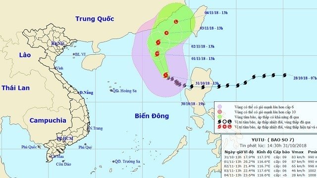
The projected location and movement of Storm Yutu. (Photo: nchmf.gov.vn)
Earlier on Tuesday afternoon, the storm crossed the Philippine island of Luzon
to enter the waters of the East Sea, becoming the seventh storm to hit the East Sea
this year.
As of 1 pm Wednesday afternoon, its
centre was located roughly 560
km northeast of Vietnam’s Hoang Sa (Paracel)
archipelago, packing winds of up to 75-90 km/h.
In the next 24 hours, the typhoon will
move north-westward at a speed of 10km per hour. By 1 pm on November 1, the
hurricane’s location is expected to be approximately 570 km northeast of Hoang Sa
archipelago, with the strongest wind near its eye at 75-90 km/h.
In the next 24-48 hours, Yutu will move
northward, travelling at 5-10km per hour. By 1 pm on November 2, its center is
forecast around 440 km
southwest of Taiwan (China), with
the strongest wind from 60-75
km/h.
In the next 48-72 hours, the storm will
move north-eastward at a speed of 5-10 km per hour, weakening into a tropical
depression. By 1 pm on November 3, the tropical low pressure is expected to be
roughly 270 km
southwest of Taiwan (China). The
strongest wind near the centre of the tropical low pressure is forecast to be
from 40-50 km/h.
Due to the influence of a current cold
spell strengthening from the north, combined with the storm’s circulation,
strong winds and rough seas are forecast for the Gulf of Tonkin
from tonight.
To actively respond to Yutu, on late
October 30, the Central Steering Committee for Disaster Prevention and Control
issued Notice No. 538/TWPCTT-VP to its member units and coastal localities from
Quang Ninh to Khanh Hoa, as well as the relevant central and local agencies, urging
for close monitoring of the storm, while informing means and vessels operating
on the sea on the position and direction of the storm to take responsive
measures. They were also asked to prepare forces and means for search and
rescue upon request.
Also on late Tuesday, the Border Guard Command
of the central province
of Thanh Hoa announced
that the unit has cooperated with the authorities of relevant coastal
localities to call on 4,992 vehicles with 20,686 workers on board to seek safe
anchorage.
Source: NDO
The emulation movement "Hoa Binh joining hands to build new-style rural areas” has been widely spreading, becoming a driving force that motivates the localities to renew rural landscapes and improve the material and spiritual lives of the residents. In this movement, the people play a central role-both as the main implementers and direct beneficiaries of its outcomes.
In response to the global digital revolution, Hoa Binh Newspaper is transforming itself into a modern and multi-platform media hub, blending cutting-edge technology with a restructured newsroom and a new generation of tech-savvy journalists.
Hoa Binh province’s Association of the Elderly recently held a conference to review the project on expanding the inter-generation self-help club model until 2025.
In a move to implement Resolution No. 57-NQ/TW, issued on December 22, 2024 by the Politburo, which targets breakthroughs in science-technology development, innovation, and digital transformation, the Hoa Binh provincial Department of Health has issued a plan to roll out the "Digital Literacy for All” campaign within the local health sector.
An Nghia Commune (Lạc Sơn District) is one of the communes that achieved the tha standard of the national new rural area in 2018. Entering a new development phase, the commune is now trying to meet the criteria for the advanced new rural development. With the strong political will and the public consensus, the commune is gradually overcoming the challenges to reach this goal, aiming for the sustainable development.


